


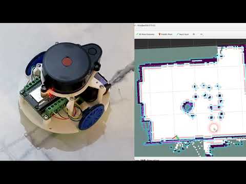
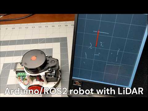
Kaia.ai is an open-source software platform to run apps on (consumer/home) robots. For now, it uses ROS2 for mapping/navigation/SLAM and Arduino-compabile firwmare.
Here is a current 3/2025 brief demo (I have not released the apps setup yet).
Here are current 3/2025 build, setup, bring-up and operation instructions.
Here are troubleshooting instructions.
Here is the technical support forum.
Kaia.ai robotics software platform is actively evolving and currently consists of these parts:
- Cloud software infrastructure (TODO)
- robot skills store (TODO)
- Micro-ROS Arduino library for Kaia.ai-compatible robots repo
- Micro-ROS LiDAR telemetry receiver package
- End-user and development ROS2 Docker images repo
- Robot Gazebo simulation ROS2 package
- Kaia.ai Python ROS2 software wrapper package
- Robot operation ROS2 repo, including SLAM mapping, navigation, frontier exploration, etc.
- Robot keyboard teleoperation package
- WebRTC-based image/video/data streaming
- Python-based image/audio sensing, processing (ML), decision making (ML/AI), robot face animation (TODO)
- Maker's Pet Loki 200mm 3D-printed pet robot
- Maker's Pet Fido 250mm 3D-printed pet robot
- Maker's Pet Snoopy 300mm 3D-printed pet robot
- Maker's Pet Mini 125mm 3D-printed educational robot
- Add your own version to the list
- YDLIDAR X4 (default), X2/X2L, X3, X3PRO, SCL
- Neato XV11
- Xiaomi Roborock 1st gen LDS02RR (~$16 off AliExpress including shipping)
- SLAMTEC RPLIDAR A1
- 3irobotix Delta-2A, Delta-2B, Delta-2G
- LDROBOT LD14P
- Camsense X1
The entire up-to-date list of supported LiDAR is here.
There are two ways to install ROS2 and Kaia.ai on your PC - using Docker (Windows, Linux) or Ubuntu 24.04 (physical PC of virtual machine). Follow the installation instructions here.
Watch build, setup and bringup videos
- Note: these videos are outdated; updated videos will be published shortly for Maker's Pet Mini
The Kaia.ai Docker image contains ROS2 and micro-ROS pre-configured with additional Kaia.ai ROS2 packages.
Open a Windows command shell or Windows PowerShell window and type the command below. This should give you a bash prompt.
Note that your c:\maps will be mapped to /root/maps to store navigation maps. Feel free to change c:\maps path to a more suitable location, e.g. c:\Users\MyUserName\maps.
# Windows WSL2
docker pull kaiaai/kaiaai:iron
docker run --name makerspet -it --rm -v c:\maps:/root/maps -p 8888:8888/udp -p 4430:4430/tcp -e DISPLAY=host.docker.internal:0.0 -e LIBGL_ALWAYS_INDIRECT=0 kaiaai/kaiaai:iron

# Ubuntu
sudo docker pull kaiaai/kaiaai:iron
sudo docker run --name makerspet -it --rm -v ~/maps:/root/maps -p 8888:8888/udp -p 4430:4430/tcp -e DISPLAY -e QT_X11_NO_MITSHM=1 --volume="/tmp/.X11-unix:/tmp/.X11-unix:rw" --volume="${XAUTHORITY}:/root/.Xauthority" kaiaai/kaiaai:iron
Get an aditional bash prompt by opening another Windows command shell or Windows PowerShell window and typing:
# Windows WSL2
docker exec -it makerspet bash

# Ubuntu
sudo docker exec -it makerspet bash
If you installed ROS2/Kaia.ai without Docker directly on a Ubuntu PC/VM, just boot your Ubuntu PC to a bash prompt.
makerspet_mini is the default robot model. When using another robot model, change the default model using Kaia.ai CLI.
For example, the command below sets the default robot model to makerspet_loki.
kaia config robot.model makerspet_loki
# Launch the physical robot
ros2 launch kaiaai_bringup physical.launch.py

# Drive robot manually
ros2 run kaiaai_teleop teleop_keyboard

# Monitor robot sensors
ros2 launch kaiaai_bringup monitor_robot.launch.py

# Create a map while driving manually
ros2 launch kaiaai_bringup cartographer.launch.py

# Save the newly-created map
ros2 run nav2_map_server map_saver_cli -f ~/maps/map --ros-args -p save_map_timeout:=60.0
# Launch the physical robot
ros2 launch kaiaai_bringup physical.launch.py

# Specify target location;; robot self-drives using an existing map
ros2 launch kaiaai_bringup navigation.launch.py map:=$HOME/maps/map.yaml

# Launch SLAM (simultaneous localization and mapping) - navigate and map simultaneously
ros2 launch kaiaai_bringup navigation.launch.py slam:=True

# Robot automatically seeks out, self-drives to unknown locations
ros2 launch explore_lite explore.launch.py

# Save the newly-created map
ros2 run nav2_map_server map_saver_cli -f ~/maps/map --ros-args -p save_map_timeout:=60.0
# View parameters
ros2 node list
ros2 node info /pet
ros2 param list /pet
ros2 param dump /pet

# Get the current laser scan frequency
ros2 param get /pet lidar.scan.freq.now

# Set the desired laser scan frequency to 7 Hz
ros2 param set /pet lidar.scan.freq.target 7.0

# Get the current desired laser scan frequency
ros2 param get /pet lidar.scan.freq.target

# Reset the desired laser scan frequency to default
ros2 param set /pet lidar.scan.freq.target 0.0
# List available topics
ros2 topic list

# Get WiFi strength
ros2 topic echo /wifi_state --once

# View raw telemetry
ros2 topic echo /telemetry --once

# Get LiDAR scan data
ros2 topic echo /scan --once

# View current odometer value
ros2 topic echo /odom --once

# View current wheel rotation angles
ros2 topic echo /joint_states --once

# View current battery voltage, charge percentage
ros2 topic echo /battery_state --once

# View target velocity sent by kaiaai_telem or navigation
ros2 topic echo /cmd_vel --once
# Launch the robot in a simulation - drive manually
ros2 launch kaiaai_gazebo world.launch.py
ros2 run kaiaai_teleop teleop_keyboard
ros2 launch kaiaai_bringup monitor_robot.launch.py

# Launch the robot in a simulation - robot self-drives around
ros2 launch kaiaai_gazebo world.launch.py
ros2 launch kaiaai_gazebo self_drive_gazebo.launch.py
ros2 launch kaiaai_bringup monitor_robot.launch.py

# Launch the robot in a simulation - let it navigate automatically using an existing map
ros2 launch kaiaai_gazebo world.launch.py
ros2 launch kaiaai_bringup navigation.launch.py use_sim_time:=true \
  map:=/ros_ws/src/kaiaai_gazebo/map/living_room.yaml

# Launch the robot in a simulation - navigate and create a map simultaneously; save the map
ros2 launch kaiaai_gazebo world.launch.py robot_model:=makerspet_loki
ros2 launch kaiaai_bringup navigation.launch.py use_sim_time:=true slam:=True
ros2 run nav2_map_server map_saver_cli -f ~/maps/map --ros-args -p save_map_timeout:=60.0
# Launch the robot in a simulation - create, save a map; robot self-drives around trivially
ros2 launch kaiaai_gazebo world.launch.py
ros2 launch kaiaai_bringup cartographer.launch.py use_sim_time:=true
ros2 launch kaiaai_gazebo self_drive_gazebo.launch.py
ros2 run nav2_map_server map_saver_cli -f ~/maps/living_room_map --ros-args -p save_map_timeout:=60.0

# Launch the robot in a simulation - navigate and create a map simultaneously
# Robot seeks out, self-drives to unknown locations to complete the mapping
ros2 launch kaiaai_gazebo world.launch.py
ros2 launch kaiaai_bringup navigation.launch.py use_sim_time:=true slam:=True
ros2 launch explore_lite explore.launch.py
ros2 run nav2_map_server map_saver_cli -f ~/maps/map --ros-args -p save_map_timeout:=60.0

# Launch the robot in a simulation - navigate and create a map simultaneously
# Robot seeks out, self-drives to unknown locations to complete the mapping, saves map
ros2 run auto_mapper auto_mapper map_path:=/ros_ws/map.yaml
ros2 launch kaiaai_gazebo world.launch.py
ros2 launch kaiaai_bringup navigation.launch.py use_sim_time:=true slam:=True

# Launch the robot in a simulation - navigate and create a map simultaneously
# Robot seeks out, self-drives to unknown locations to complete the mapping
ros2 launch kaiaai_gazebo world.launch.py
ros2 launch kaiaai_bringup navigation.launch.py use_sim_time:=true slam:=True
ros2 run nav2_wfd explore
You can set lidar_model to any of these supported models: XIAOMI-LDS02RR, YDLIDAR-X4, YDLIDAR-X3,
YDLIDAR-X3-PRO, YDLIDAR-X2-X2L, YDLIDAR-SCL, NEATO-XV11, 3IROBOTIX-DELTA-2A, 3IROBOTIX-DELTA-2B,
3IROBOTIX-DELTA-2G, LDROBOT-LD14P, CAMSENSE-X1, SLAMTEC-RPLIDAR-A1.
# Inspect, edit robot's URDF model
ros2 launch kaiaai_bringup inspect_urdf.launch.py
ros2 launch kaiaai_bringup edit_urdf.launch.py

# Convert URDF robot model file into SDF Gazebo simulation model file
ros2 run kaiaai_gazebo urdf2sdf.sh /ros_ws/src/makerspet_loki
cd /ros_ws && colcon build --symlink-install --packages-select makerspet_loki
Commands physical.launch.py, teleop_keyboard, monitor_robot.launch.py, cartographer.launch.py,
navigation.launch.py, inspect_urdf.launch.py, edit_urdf.launch.py and world.launch.py accept
an optional robot_model argument to override the default robot package setting, per launch.
The physical.launch.py also accepts an optional lidar_model argument to override the default
LiDAR model choice.
For example, the command below will use the makerspet_loki robot model and YDLIDAR-X3 LiDAR instead of the defaults.
ros2 launch kaiaai_bringup physical.launch.py robot_model:=makerspet_loki lidar_model:=YDLIDAR-X3
Initial versions of packages in this repo are based on ROBOTIS Turtlebot3 code
v0.10.0 in debug
- converted kaiaa from metapackage to Pyhon package
- kaia CLI sets default robot model
- added YDLIDAR SCL
- added intensity telemetry publication
- added Maker's Pet Mini
- added LiDAR orientation_deg
v0.9.0
- added WebRTC, web server, OpenCV launch
- added Camsense X1 LiDAR
v0.8.0
- added kaiaai_python ROS2 package
- added 3irobotix Delta-2A 230400 baud (vs 115200)
- added 3irobotix Delta-2B
- bugfix missing first scan point
v0.7.0
- kaiaai_telemetry
- switched to KaiaTelemetry2 message
- publish /battery_state
- publish /wifi_state RSSI
- discard_broken_scans, needs more debug
- added LDROBOT LD14P
v0.6.0 2/11/2024
- added 3irobotix Delta-2A, Delta-2G
2/5/2024
- added LiDAR laser distance scan sensors support
- YDLIDAR X3, X3-PRO
- Neato XV11
- RPLIDAR A1
- split kaiaai_telemetry config into default and custom
kaiaai/kaiaai_telemetry/config/telem.yamlis the default configmakerspet_loki/config/telem.yamlis the custom config for the Loki robot modelmakerspet_fido/config/telem.yamlis the custom config for the Fido robot modelmakerspet_snoopy/config/telem.yamlis the custom config for the Snoopy robot model
1/28/2024
- added YDLIDAR X2 support to kaiaai_telemetry
1/21/2024
- kaiaai_telemetry now supports multiple LiDAR laser distance scan sensors
- added Xiaomi Mi LDS02RR; default is YDLIDAR X4
12/11/2024
- added fully automatic self-driving to map exploration (frontier exploration m-explore)
- I think this code needs debug
12/7/2024
- added Nav2 SLAM (as an alternative to Google Cartographer)
- Nav2 SLAM enables driving autonomously to a set goal while mapping (and while the map is still incomplete)
- increase the map saver default timeout
- fixed the map saving command timing out on my "slow" laptop