Matlab Script to get a elevation profile along a path defined between two points with n resolution samples.
Just download getElevationsPath.m file from this repository and paste it on the folder of the script that is calling this function.
GETELEVATIONSPATH queries Google Maps API webservice for ground elevations
along the path between the latitudes and longitues provided with n
resolution samples.
elevation = getElevationsPath(latitude1, longitude1, latitude2,
longitude2, resolution, 'key', 'YOUR-API-KEY');
Returns <resolution> points of elevation from the path from
Point1(latitude1, longitude1) to Point2 (latitude2, longitude2).
[elevation, resolution] = getElevationsPath(latitude1, longitude1,
latitude2, longitude2, resolution, 'key', 'YOUR-API-KEY');
Returns <resolution> points of elevation and resolution from the path
from Point1(latitude1, longitude1) to Point2 (latitude2, longitude2).
[elevation, resolution, latitudes, longitudes] =
getElevationsPath(latitude1, longitude1, latitude2, longitude2,
resolution, 'key', 'YOUR-API-KEY');
Returns <resolution> points of elevation, resolution, latitudes and
longitudes from the path from Point1(latitude1, longitude1) to Point2
(latitude2, longitude2).
------------------------------------------------------------------------
Example:
Get an area profile. Area vertex are:
VERTEX LAT LONG
Up Left Corner: 39.549937, -8.819350
Up Right Corner: 39.549937, -8.761150
Down Left Corner: 39.505018, -8.819350
Down Right Corner: 39.505018, -8.761150
clearvars;
clc;
SAMPLES = 100;
API_KEY = 'YOUR-API-KEY'; % Read https://developers.google.com/maps/documentation/elevation/get-api-key
Coord1 = [39.549937, -8.819350];
Coord2 = [39.505018, -8.761150];
try
load(['backup_' num2str(SAMPLES)]);
% Sucess loaded but the number of samples are different or the
% coordinates are different. Need to request elevations again.
if length(lat_map)~=SAMPLES || lat_map(1)~=Coord1(1) || lng_map(1)~=Coord1(2) ...
|| lat_map(length(lat_map),1)~=Coord2(1) || lng_map(1,length(lng_map))~=Coord2(2)
disp('Requesting Elevations to Google');
lat = linspace(Coord1(1), Coord2(1), SAMPLES); %Latitude Points
% Preallocating memory for speed improvement
elevation_map = NaN(SAMPLES, SAMPLES);
resolution_map = NaN(SAMPLES, SAMPLES);
lat_map = NaN(SAMPLES, SAMPLES);
lng_map = NaN(SAMPLES, SAMPLES);
% Gets the area elevations.
for r=1:length(lat)
[elevation_map(r,:), resolution_map(r,:), lat_map(r,:), lng_map(r,:)] = getElevationsPath(lat(r), Coord1(2), lat(r), Coord2(2), SAMPLES, 'key', API_KEY);
end
save(['backup_' num2str(SAMPLES)], 'elevation_map', 'resolution_map', 'lat_map', 'lng_map');
end
catch
disp('Requesting Elevations to Google');
lat = linspace(Coord1(1), Coord2(1), SAMPLES); %Latitude Points
% Preallocating memory for speed improvement
elevation_map = NaN(SAMPLES, SAMPLES);
resolution_map = NaN(SAMPLES, SAMPLES);
lat_map = NaN(SAMPLES, SAMPLES);
lng_map = NaN(SAMPLES, SAMPLES);
% Gets the area elevations.
for r=1:length(lat)
[elevation_map(r,:), resolution_map(r,:), lat_map(r,:), lng_map(r,:)] = getElevationsPath(lat(r), Coord1(2), lat(r), Coord2(2), SAMPLES, 'key', API_KEY);
end
save(['backup_' num2str(SAMPLES)], 'elevation_map', 'resolution_map', 'lat_map', 'lng_map');
end
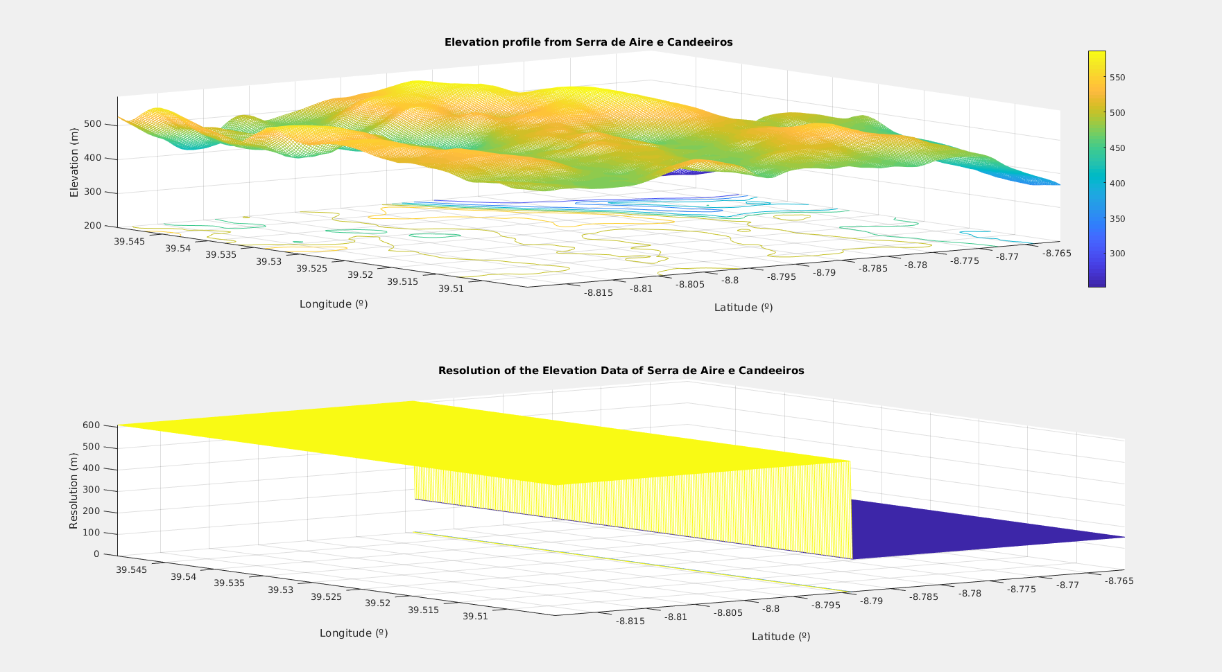
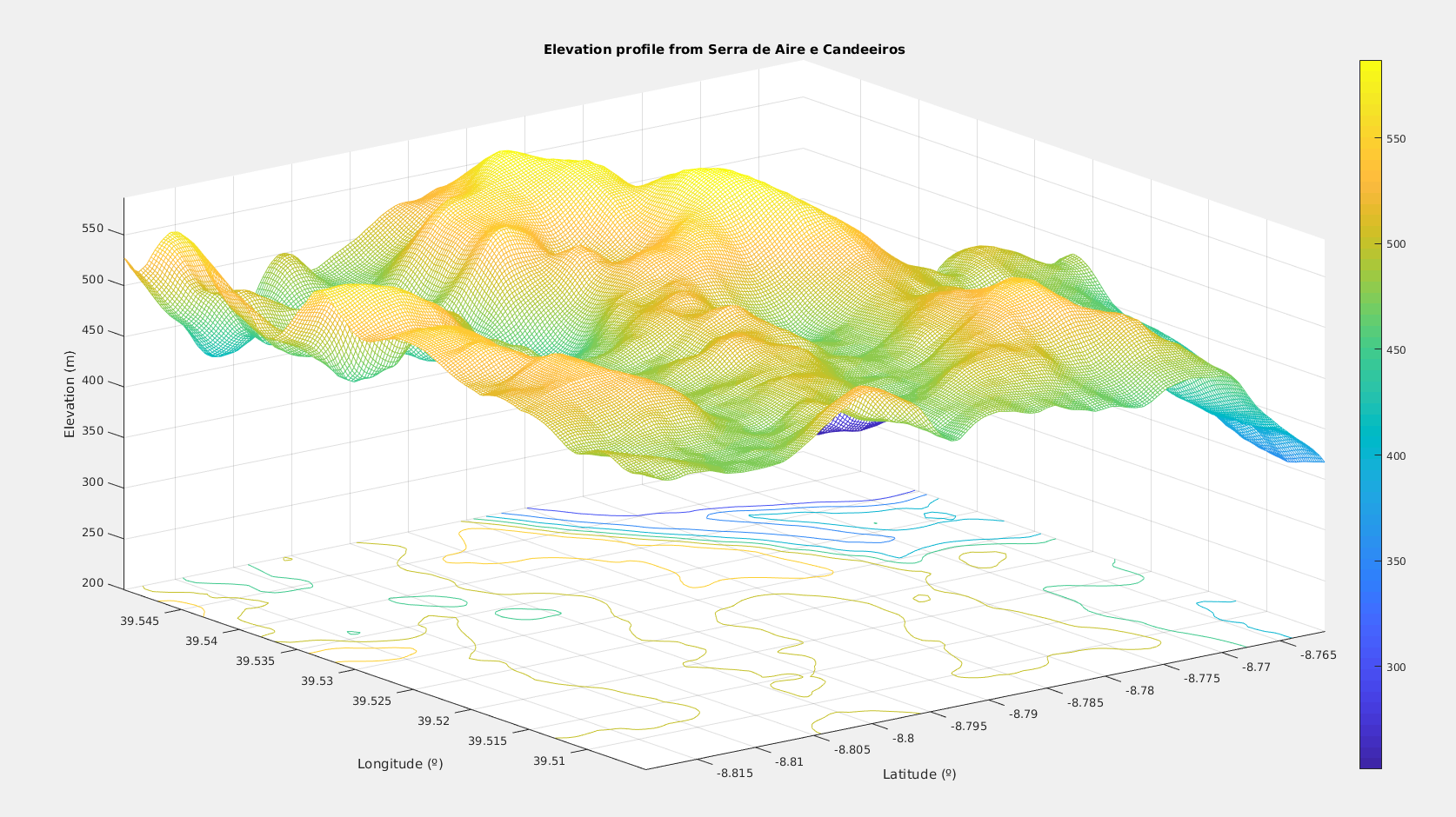
disp('Displaying Data');
% Displays the data
figure('Name','Elevation');
subplot(2,1,1);
meshc(lng_map(1,:), lat_map(:,1), elevation_map);
title('Elevation profile from Serra de Aire e Candeeiros');
xlabel('Latitude (º)');
ylabel('Longitude (º)');
zlabel('Elevation (m)');
colorbar;
subplot(2,1,2);
meshc(lng_map(1,:), lat_map(:,1), resolution_map);
title('Resolution of the Elevation Data of Serra de Aire e Candeeiros');
xlabel('Latitude (º)');
ylabel('Longitude (º)');
zlabel('Resolution (m)');
------------------------------------------------------------------------
MAIN ADVANTAGES (compares to getElevations from Jarek Tuszynski):
- Only consumes one API request for n resolution points between the
path, instead of x API request from the n points from the request
of the original script;
- Easier to use in some cases, mainly when you need to get a
elevation profile of a big area (elevation profile line by line)
THIS SCRIPT IS A MODIFIED VERSION OF GetElevation Script from:
Author: Jarek Tuszynski (jaroslaw.w.tuszynski@leidos.com)
Documentation: https://developers.google.com/maps/documentation/elevation/
MODIFIED VERSION AUTHOR: José Rosa
Github: https://github.com/pinxau1000/Matlab-Google-Elevation-API
Tested on Matlab R2017a
A resolution value, indicating the maximum distance between data points
from which the elevation was interpolated, in meters. This property will
be missing if the resolution is not known. Note that elevation data becomes
more coarse (larger resolution values) when multiple points are passed.
To obtain the most accurate elevation value for a point, it should be queried
independently.